

Invest in Wheat Ridge
Wheat Ridge moves forward on $75 million bond program with corridor redesigns, sidewalk fixes and stormwater repairs
Survey crews will soon appear on 38th Avenue. Sidewalk dead-ends near schools and parks are slated for repair. And after a string of sinkholes forced more than $2 million in emergency fixes, the city is getting serious about what's underground.
Two years after Wheat Ridge voters approved the $75 million "Next Chapter" bond program, 2026 marks the year the investment starts becoming visible.
The Wheat Ridge City Council recently approved a $636,100 design contract for the 38th Avenue Refresh project, which will overhaul the corridor from Wadsworth Boulevard to Sheridan Boulevard. Conceptual plans are expected in early 2027.
The project aims to improve sidewalks, lighting, landscaping and public gathering spaces while largely preserving the existing roadway configuration. Residents can expect to see survey crews and traffic analysis in the coming months, along with targeted outreach to nearby businesses and property owners.
Further west, design work on the stretch of 38th Avenue between Youngfield Street and Kipling Street is approximately 60% complete. That 1.75-mile corridor is planned for conversion to a two-lane street with dedicated bike lanes and improved pedestrian facilities. The design preserves mature trees, minimizes right-of-way acquisition and targets improvements to specific areas rather than applying changes uniformly across the full corridor.
The city has hired a consultant to design priority sidewalk connections, with construction anticipated in 2026 and 2027. Projects are being selected based on proximity to schools and parks, connectivity to the existing sidewalk network and the feasibility of working around utilities and right-of-way constraints.
Pipe failures have already cost the city more than $2 million in emergency repairs over the past two years, with sinkholes emerging at locations including Independence Street, Miller Street and Hoyt Street. City officials say aging underground infrastructure, much of it under-maintained for decades, is increasingly at risk as fewer opportunities remain for traditional stormwater detention.
Wheat Ridge adopted a Stormwater Master Plan in May 2025 to guide long-term system improvements. Repair work is ongoing, funded through 2J bond dollars.
Voters approved the 2J bond program in 2023. Bonds were issued in late 2024, and the city is now moving from planning into implementation across transportation, drainage and infrastructure projects.
Additional public input opportunities will be announced as projects advance from design into construction.
-
38th Avenue West Improvements (Kipling to Youngfield)
Share 38th Avenue West Improvements (Kipling to Youngfield) on Facebook Share 38th Avenue West Improvements (Kipling to Youngfield) on X (formerly Twitter) Share 38th Avenue West Improvements (Kipling to Youngfield) on Linkedin Email 38th Avenue West Improvements (Kipling to Youngfield) linkProject Description
This project will improve safety and multimodal travel along 1.75 miles of 38th Avenue between Youngfield Street and Kipling Street.
Improving conditions for people walking, biking, and driving along this corridor has been a long-standing community priority. In 2023, the city launched a planning study to identify improvements that would enhance safety, improve mobility, maintain vehicle access, and address stormwater needs. The recommended design was developed through technical analysis and extensive public input.
Planned improvements include continuous sidewalks on both sides of the street, dedicated bike lanes in both directions, targeted turn-lane modifications, and upgraded pedestrian crossings. TheContinue reading
-
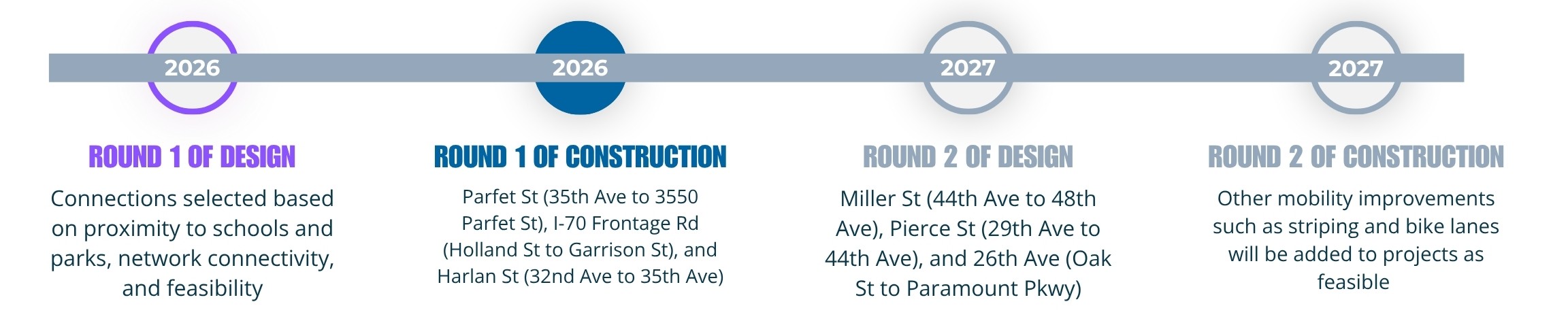
Priority Sidewalk Connections
Share Priority Sidewalk Connections on Facebook Share Priority Sidewalk Connections on X (formerly Twitter) Share Priority Sidewalk Connections on Linkedin Email Priority Sidewalk Connections linkProject Description
This project will design and construct missing sidewalk segments along key pedestrian routes to improve safety, accessibility, and connectivity throughout Wheat Ridge.
Like many communities, Wheat Ridge’s transportation network was originally designed primarily for cars, leaving gaps in the sidewalk system. Over the past two decades, residents have increasingly identified walking access and safety as community priorities. This project addresses those needs by filling critical sidewalk gaps near schools, parks, and other destinations.
Round 1 segments, scheduled for construction in 2026, include:
- Parfet Street (35th Avenue to 3550 Parfet Street)
- I-70 Frontage Road (Holland Street to GarrisonContinue reading
-
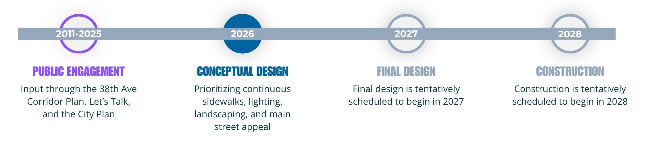
38th Avenue Main Street Refresh (Sheridan to Wadsworth)
Share 38th Avenue Main Street Refresh (Sheridan to Wadsworth) on Facebook Share 38th Avenue Main Street Refresh (Sheridan to Wadsworth) on X (formerly Twitter) Share 38th Avenue Main Street Refresh (Sheridan to Wadsworth) on Linkedin Email 38th Avenue Main Street Refresh (Sheridan to Wadsworth) linkProject Description
This project will advance the long-term vision of 38th Avenue as Wheat Ridge’s Main Street by enhancing safety, connectivity, and placemaking between Sheridan and Wadsworth Boulevards.
The corridor has been identified as a redevelopment priority for more than a decade. The 2011 38th Avenue Corridor Plan established a vision for transforming the area into a vibrant, walkable destination. Since then, the city has made significant investments, including roadway improvements, streetscape enhancements, zoning updates, intersection reconstruction, and construction of The Green at 38th.
The Main Street Refresh builds on these investments and moves the community closer to achievingContinue reading
-
Stormwater System Maintenance
Share Stormwater System Maintenance on Facebook Share Stormwater System Maintenance on X (formerly Twitter) Share Stormwater System Maintenance on Linkedin Email Stormwater System Maintenance linkProject Description
This project addresses critical maintenance needs within Wheat Ridge’s aging stormwater system to reduce flooding risks and protect neighborhoods.
Much of the city’s stormwater infrastructure was installed during the same period and has received limited reinvestment over time. In 2023, several storm sewer failures required emergency repairs, highlighting the need for ongoing maintenance and replacement.
Using 2J funds, the city has already repaired sinkholes and replaced 2,303 feet of storm pipe at eight locations during 2025 and 2026. The city will continue monitoring system conditions and making necessary repairs to improve reliability and reduce future risks.
Community Support
Continue reading -
How Were the Projects on the Ballot Decided?
Share How Were the Projects on the Ballot Decided? on Facebook Share How Were the Projects on the Ballot Decided? on X (formerly Twitter) Share How Were the Projects on the Ballot Decided? on Linkedin Email How Were the Projects on the Ballot Decided? linkThe unfunded capital improvement projects being approved by voters in the extension of the .5 cent sales tax were developed as a direct result from resident feedback and deliberate planning.
Planning and outreach efforts included the following:
NRS Update (2019)
The Neighborhood Revitalization Strategy (NRS) began in the early 2000s with the goal of facilitating a healthy housing market, attracting commercial investment, and supporting a vibrant community. The 2019 NRS was a report card or checkup on that progress. The city looked at the data and took the temperature of residents.
The NRS raised the bar in terms of publicContinue reading


Who's Listening
-
Communications and Engagement Manager

Phone (303) 235-2877 Email aharrison@ci.wheatridge.co.us
City Council Meetings and Study Sessions Discussing .5 Cent Sales Tax Extention
-
 Discussion on .5 Cent Sales Tax Projects
-
 This city council study session held a public hearing on the proposed ballot language to extend or expire the existing .5 cent sales tax. Council unanimously approved adding the language to this November's ballot.
-
 During this meeting city council voted to hold a public hearing on the proposed ballot language on August 28.
-
 In this meeting results of the first survey exploring the extension of the .5 cent sales tax were discussed.
-
 During this session council reviewed the results of the second survey exploring voter interest in extending the existing .5 cent sales tax.
