
City Plan: A New Comprehensive Plan for Wheat Ridge
About the City Plan
Wheat Ridge City Council adopted the City Plan, often called a comprehensive plan, on September 8, 2025. This plan articulates our community’s vision for the next 15 years, establishes shared values, and identifies priorities for the future. It also provides direction on issues such as what land uses should be where, how people get around, access to housing, and supporting the local economy. The City Plan provides the framework for many decisions for years to come. Check out some of the plan's key takeaways below.
Check out the Executive Summary here.
Dive deeper by exploring the full City Plan document here.
Explore the important maps in the City Plan here.
All Appendices can be found here.
What's next?
Now, we will begin implementing this plan. Check back for more details soon!
-
Thank You for Participating, Wheat Ridge!
Share Thank You for Participating, Wheat Ridge! on Facebook Share Thank You for Participating, Wheat Ridge! on X (formerly Twitter) Share Thank You for Participating, Wheat Ridge! on Linkedin Email Thank You for Participating, Wheat Ridge! linkThe content and direction of this plan was guided by the community through a robust public engagement and communications process. This included:
- Four in-person open house events with approximately 515 attendees
- Four online surveys and an online map exercise that saw over 1,000 submissions
- 18 steering committee members who helped guide the process
- 100 Neighborhood Champions who went above and beyond to encourage neighbors and friends to participate
- Conversations with City Council and Planning Commission throughout the process
- Youth engagement with over 100 students at Wheat Ridge High School
- Hundreds of in-person conversations at community events like Performance in the Park and Carnation Festival
- Emails, postcards, yard signs, flyers, coasters, swag, social media posts, and more to help spread the word
Thank you to everyone who participated in the City Plan process! Each comment, conversation, and survey response made this plan better.
Learn more about the process and what we heard in each engagement phase on pages 18-27 of the plan and in Appendix G.

-
Core Values, Planning Principles, and Planning Priorities
Share Core Values, Planning Principles, and Planning Priorities on Facebook Share Core Values, Planning Principles, and Planning Priorities on X (formerly Twitter) Share Core Values, Planning Principles, and Planning Priorities on Linkedin Email Core Values, Planning Principles, and Planning Priorities linkThe City Plan is built upon a set of core values, planning principles, and planning priorities that were determined by the community in the City Plan process.
 Core Values
Deeply-held, widely shared beliefs in Wheat Ridge that serve as building blocks for our vision of the future.Independent-Minded - We go our own way. - 72% Agreed or Mostly Agreed
Inclusive - Our community is welcoming to all. - 82% Agreed or Mostly Agreed
Forward-Looking - We are responsible to the future. - 87% Agreed or Mostly Agreed Planning Principles
Criteria for public decision-making that ensure adherence to the community’s core values.
Serve a mix of incomes - We will ensure that new investment benefits people across all income levels. - 77% Agreed or Mostly Agreed
Preserve our “patchwork quilt” - We will celebrate and enhance the unique character of areas within Wheat Ridge. - 89% Agreed or Mostly Agreed
Focus on sustainability - We will act as good stewards of the environment. 86% Agreed or Mostly Agreed
Strengthen the City’s fiscal position - We will make decisions about public investments with an eye on the future. - 88% Agreed or Mostly Agreed Planning Priorities
Important, long-term projects that must be done right in order for the community to be successful.Improved Retail and Business Environment – We will support the business community and cultivate the kinds of places where residents want to shop, dine, and visit. - 78% Agreed or Mostly Agreed
38th Ave. from Lutheran Legacy Campus to Harlan St. – We will continue shaping this section of 38th Avenue into Wheat Ridge’s Main Street corridor - 78% Agreed or Mostly Agreed
Network of Pedestrian and Bicycle Facilities Across the City – We will provide a system for pedestrians and cyclists to move between important locations more easily. - 86% Agreed or Mostly Agreed
Proactive Infrastructure Management – We will catch up on deferred infrastructure maintenance and keep pace into the future. - 95% Agreed or Mostly AgreedLearn more about our values, principles, and priorities on pages 32-59 of the plan.
-
Our Character and Development Vision
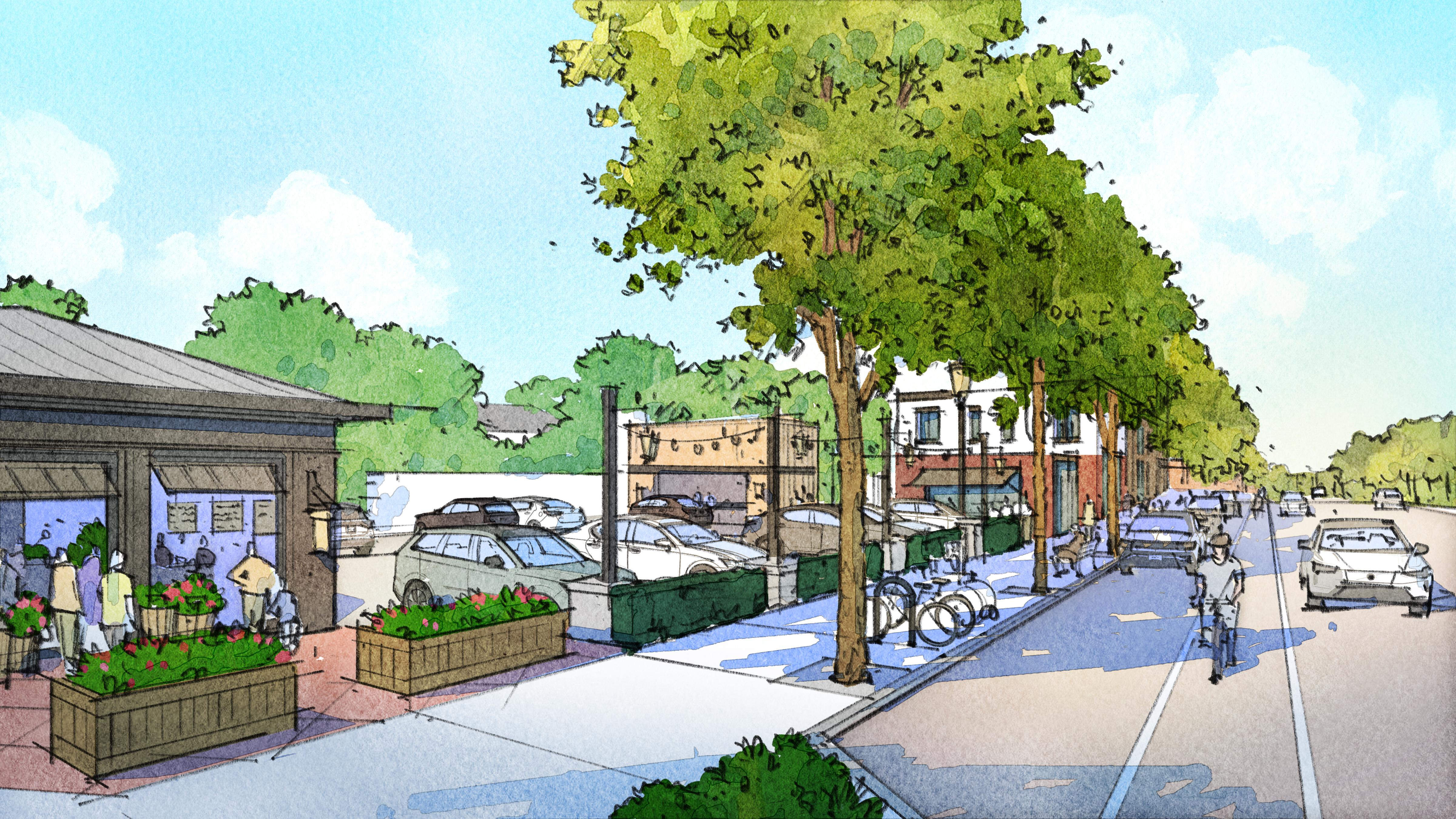
Share Our Character and Development Vision on Facebook Share Our Character and Development Vision on X (formerly Twitter) Share Our Character and Development Vision on Linkedin Email Our Character and Development Vision linkA cornerstone of the community’s vision is that Wheat Ridge become the best possible version of itself while maintaining the character that makes it feel like Wheat Ridge.
When it comes to character, the City Plan aims to achieve these four outcomes:
- Evolution of Our Places - We want to see incremental change that is carefully curated so we can evolve while maintaining our character of distinct areas with their own look and feel.
- Peaceful Coexistence - We want to ensure that new development peacefully coexists with existing neighborhoods.
- Improved Connectivity and Access - We want future investments and improvements to help people move around town more easily, especially on foot or by bicycle.
- Making Great Places - We want to see improvements to the space between buildings and the curb that enhance the experience of spending time in our public spaces.
Learn more about how the city can work to achieve the outcomes listed above on pages 68-107 of the plan. Check out the important maps related to our character and development vision here.
 Explore how our character and development vision could come to life in specific locations in Wheat Ridge on pages 112-132 of the plan.
 -
Creating Our Future
Share Creating Our Future on Facebook Share Creating Our Future on X (formerly Twitter) Share Creating Our Future on Linkedin Email Creating Our Future linkThe City Plan paints a vivid picture of where the community wants to go. That vision can be summarized in three goals that articulate what Wheat Ridge wants. Each of these goals include strategies to help us work towards those goals and specific actions that detail incremental steps to bring this plan to life.
Goal 1: Modern Infrastructure
The community’s demands for basic infrastructure functionality and quality-of-life capital investments are growing. The community understands that there is substantial catch-up work to be done on infrastructure from years past, and more keep-up work to be done in the future. The successful partnership between the community and city government is growing Wheat Ridge’s capacity to plan for, invest in, and sustain the quality and diversity of infrastructure the city needs.
Goal 2: Thoughtful Placemaking
Wheat Ridge is a place of places. Some of its places are considered important and special today, while others hold promise that they could evolve in that direction. Among our places are residential neighborhoods, corridor business districts, and parks and open space. Celebrating and positively shaping Wheat Ridge’s places means curating physical character through the proper application of tools in both private development projects and city investments in the public right-of-way.
Goal 3: Thriving Businesses and Neighborhoods
The community wants to have vibrant business and residential environments that complement each other. Neighborhoods are more livable when they offer access to amenities that residents want and need, including attractive retail options and local drinking and dining establishments. New housing accommodates additional residents who can become the new customers that local businesses need in order to thrive. At the same time, Wheat Ridge has been clear that new housing should be diverse in type and price point so the community can continue to appeal to a variety of different households.
Learn more about these goals and the strategies and actions that support them on pages 138-152 of the plan.

Who's Listening
-
Neighborhood Engagement Coordinator

Phone 303-898-3156 Email aholland@wheatridge.gov -

Phone 303-235-7063 Email sszrek@wheatridge.gov

